The ocean is often viewed as a vast, static body of water, but it is actually a dynamic and highly interconnected engine that regulates the Earth’s climate, supports global biodiversity, and underpins the international economy. From the wind-driven currents at the surface to the slow-moving “conveyor belt” in the abyssal depths, ocean circulation moves heat, carbon, and nutrients across the globe in a delicate balance.
However, as the planet warms, these fundamental systems are shifting. For businesses, ocean circulation is a material factor in supply chain resilience, regulatory compliance, and long-term strategic planning. Whether it is the Gulf Stream influencing European weather patterns or upwelling zones providing half of the world’s fish catch, the movement of the sea directly affects how companies operate, what they spend, and how they report their environmental impact.
In this article, you will learn:
✅The mechanics of movement: How wind, the Earth’s rotation, and water density drive surface and deep-ocean currents.
✅Vertical dynamics: The vital roles of upwelling and downwelling in supporting marine life and cooling the planet.
✅Business implications: Why shifts in these currents present physical, regulatory, and reputational risks to sectors ranging from shipping to finance.
✅The path forward: How frameworks like the LEAP approach help firms build resilience in a changing oceanic landscape.
By understanding the why and how of ocean circulation, you can better navigate the emerging risks and opportunities caused by ocean circulation.
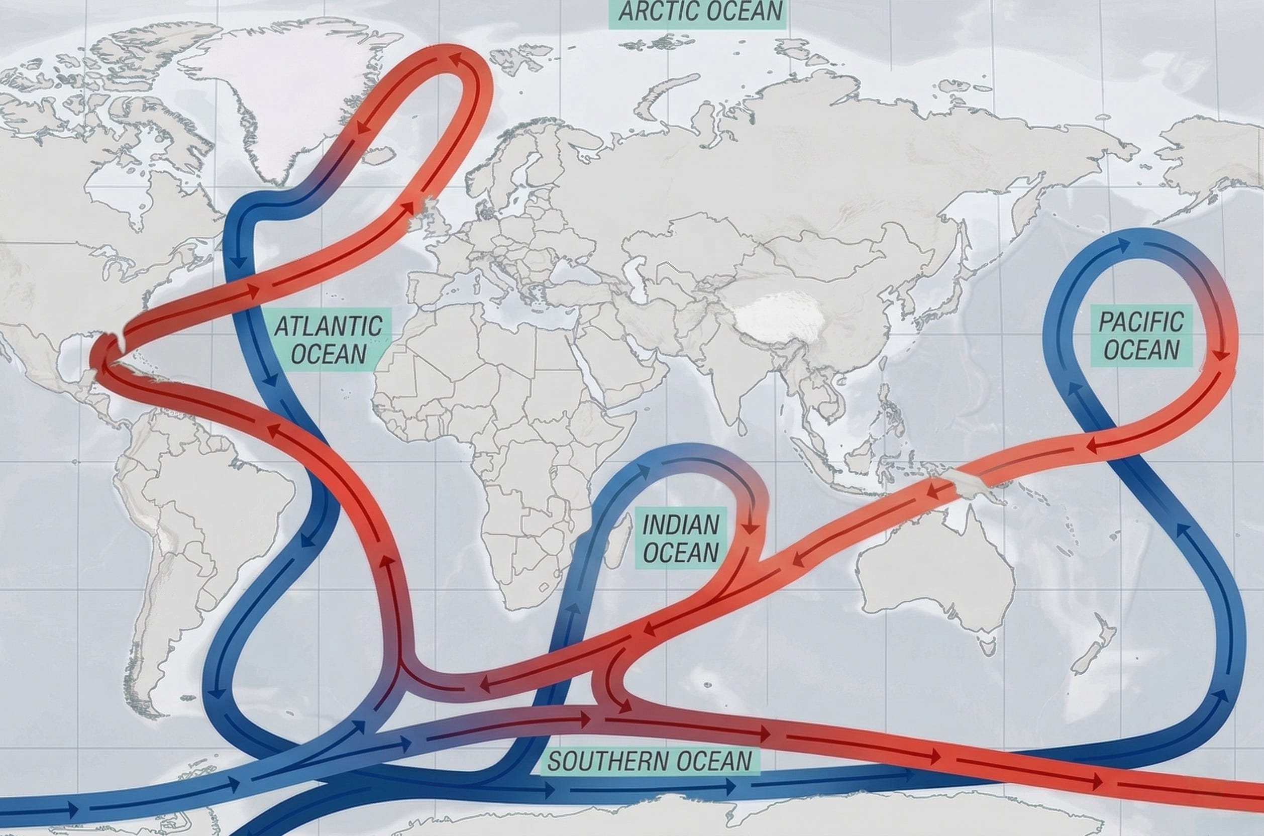
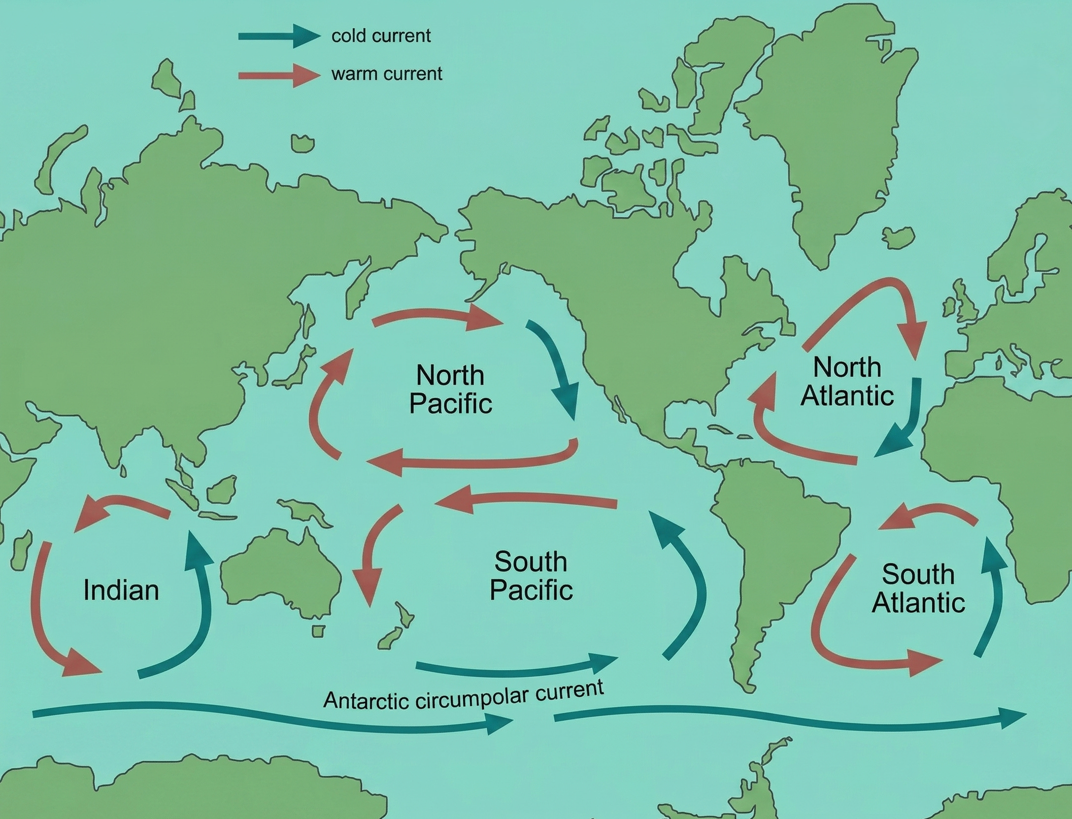
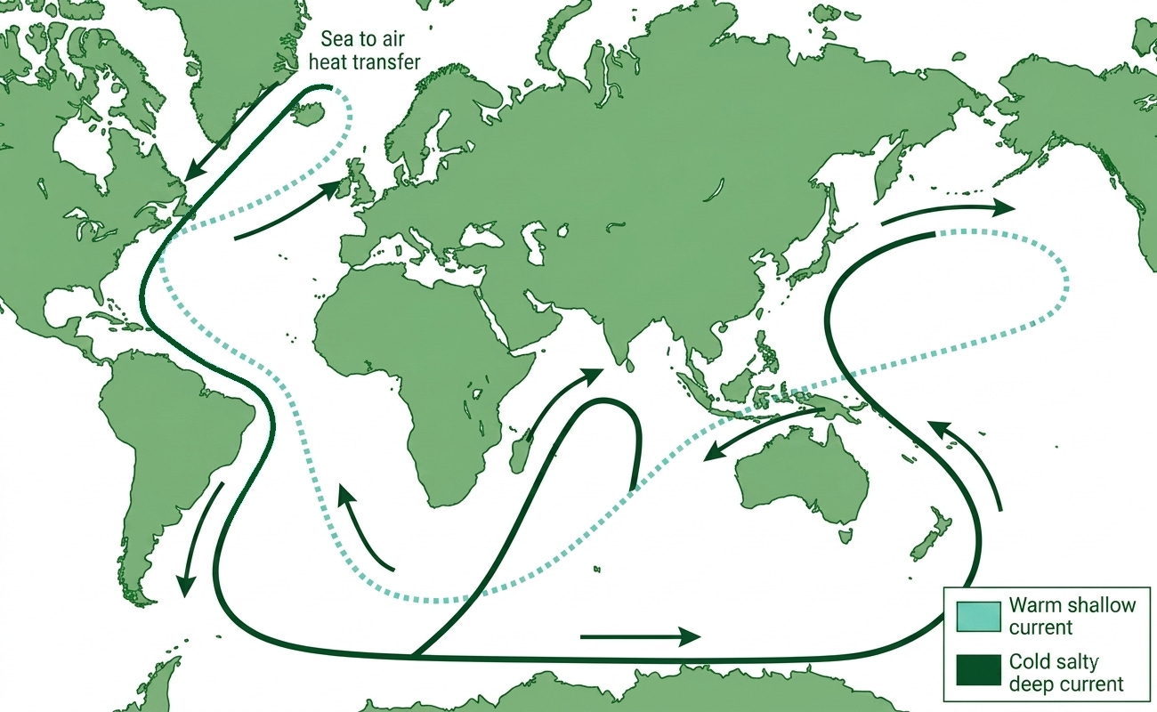
This is a simplified view of how the ocean flows:
The ocean's movement is organized into two primary systems: surface circulation and deep-ocean circulation.
While they operate at different depths and speeds, they are inextricably linked by vertical movements—the rising and sinking of water—that connect the two into one global machine. To understand how this system functions, we will first examine the engine of the surface ocean.
2. Surface ocean circulation
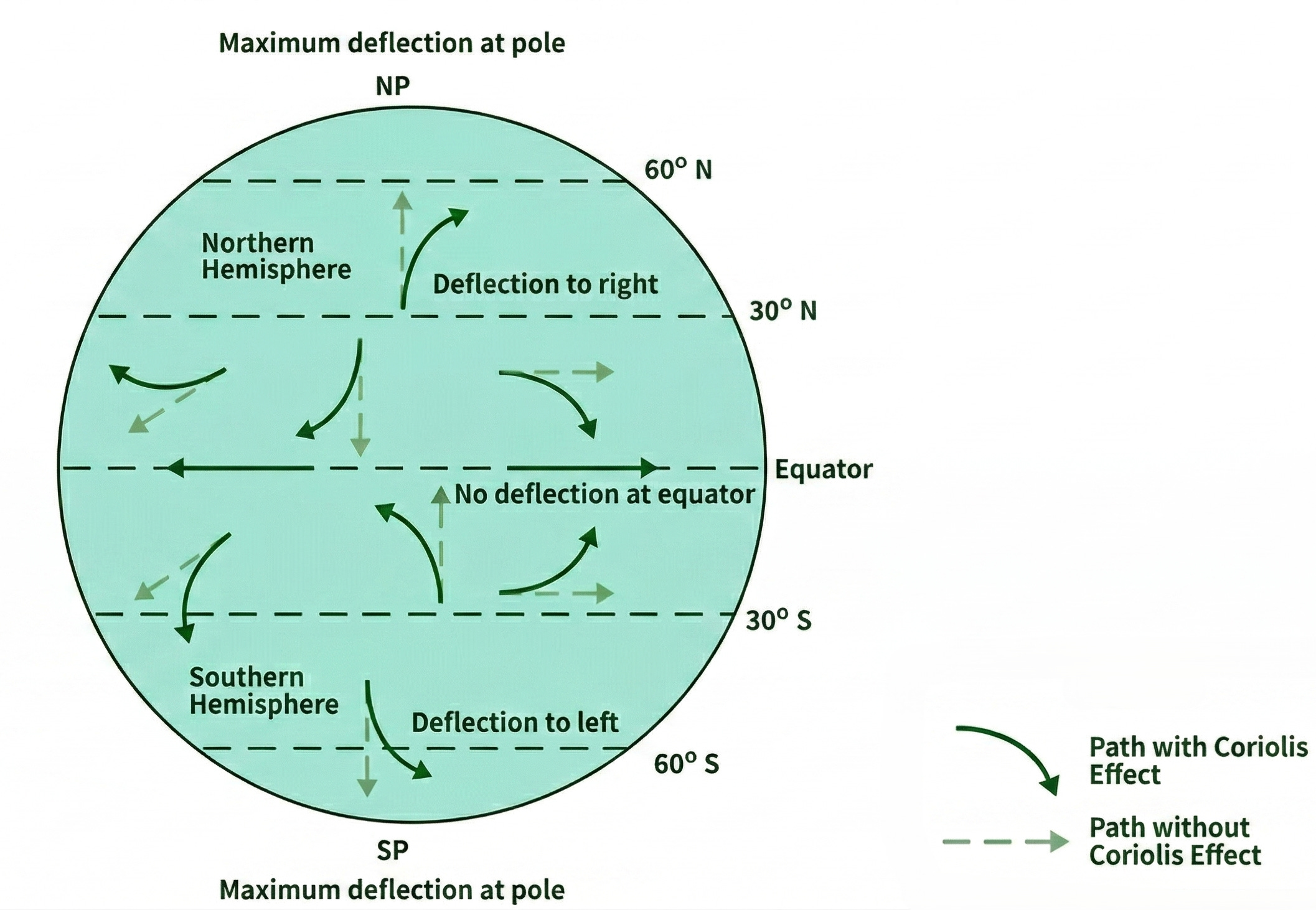
The upper few hundred meters of the ocean are predominantly driven by global wind systems, such as the tropical easterlies and mid-latitude westerlies, combined with the Earth’s rotation. As wind blows across the ocean, it transfers momentum to the surface water via friction. However, because the Earth rotates, the Coriolis effect deflects these moving waters to the right in the Northern Hemisphere and to the left in the Southern Hemisphere.
The Coriolis effect is the “curve” that happens because the Earth is spinning while things are moving over it.
Imagine you are standing in the center of a spinning merry-go-round and you try to throw a ball straight to a friend standing on the outer edge.
The curve: As the ball flies through the air, the merry-go-round keeps spinning. By the time the ball reaches the edge, your friend has moved. To you, it looks like the ball curved away from them, even though you threw it straight.
Earth is the merry-go-round: Our planet is spinning just like that ride. Because different parts of the Earth move at different speeds (the equator spins much faster than the poles), anything traveling long distances, like wind or ocean water, gets left behind or pushed ahead.
The result: Instead of moving in a straight line, the wind is forced to veer off course. This creates the massive circular swirls we see in hurricanes and ocean currents.
The simple rule to remember:
Northern Hemisphere: Things curve to the right.
Southern Hemisphere: Things curve to the left.
This deflection caused by the Coriolis effect creates a pattern known as the Ekman spiral, where each successive deeper layer of water moves slower and turns further away from the wind’s original direction. The net result of this spiraling motion is Ekman transport, which describes the overall movement of the upper water column at a 90-degree angle to the wind. So:
The wind pushes the surface water.
The Coriolis effect turns that surface water slightly.
That top layer drags the layer beneath it, which turns even further and moves even slower.
The final result is Ekman transport: the total volume of water ends up moving at a 90-degree angle to the direction the wind is blowing.
If you are interested, you can learn more about Ekman transport in this video:
Because the wind is pushing water at an angle, it eventually piles up in the middle of the ocean, creating hills of water up to two meters high.
Gravity tries to pull this water downhill, but the Coriolis effect keeps pushing it back toward the center. This tug-of-war creates a balanced, circular flow called a Subtropical Gyre (named for their location in the “subtropics” and their circular “gyrating” shape). There are five gyres:
The currents on the western side of the ocean are much stronger and warmer than those on the eastern side. Because the Earth rotates from West to East, it squashes the ocean’s hills of water against the western coastlines.
On this western side (like the Gulf Stream near the US or the Kuroshio near Japan), the water is squeezed into a very tight space. Like water shooting out of a garden hose when you put your thumb over the end, the current becomes exceptionally fast, narrow, and deep. Because these currents move so quickly from the equator, they are carrying tropical heat thousands of miles toward the poles before the water has a chance to cool down.
On the eastern side of the ocean (like near California or Africa), the water has plenty of room to spread out. This results in currents that are wide, shallow, and slow. These currents carry water from the cold poles back toward the equator. Because they move so slowly and are spread so thin, they don't have the energy of the western currents. Instead, they linger along the coast, keeping the nearby land much cooler and drier than it would be otherwise.
Takeaway The upper ocean’s circulation is a sophisticated chain reaction: global winds transfer momentum to the surface, but the Coriolis effect deflects this movement, resulting in Ekman transport that moves water at a 90-degree angle to the wind. This process piles water into “hills,” forming massive circular gyres. Due to the Earth’s eastward rotation, these gyres are offset, creating Western Intensification—where western currents (like the Gulf Stream) become fast, narrow heat-conveyors, while eastern currents remain slow, shallow, and cool.
3. Vertical movement of the ocean
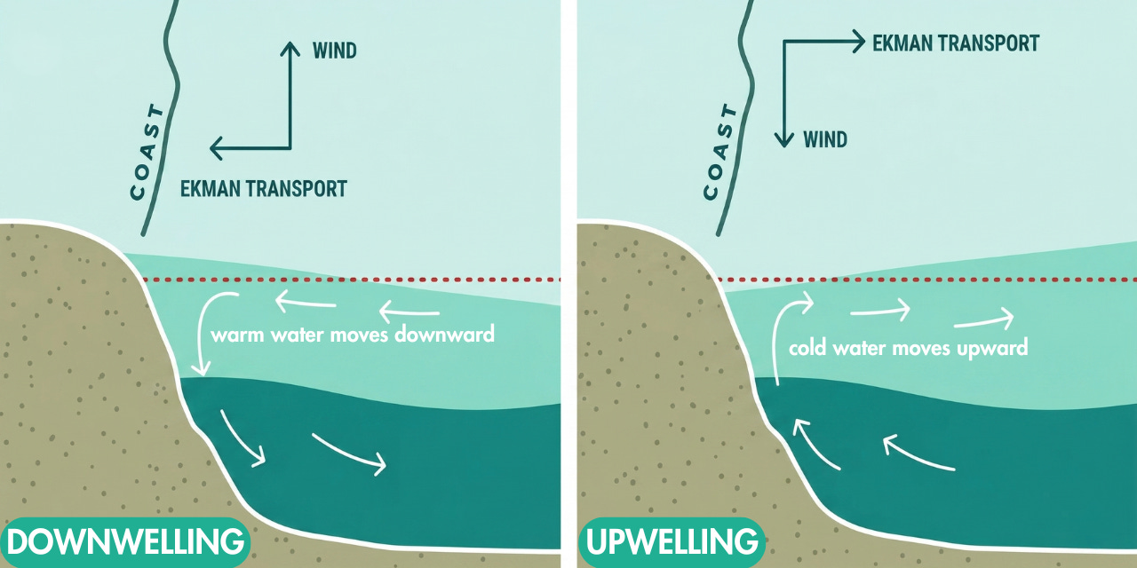
This surface movement also drives vertical water motion. Diverging surface waters caused by Ekman transport lead to Ekman suction (upwelling), which draws cold, nutrient-rich deep water up to the surface. Conversely, where waters converge and pile up, Ekman pumping (downwelling) forces warm surface water down into the depths.
Ekman transport takes place within a relatively thin layer at the top of the ocean, typically extending only 100 to 150 meters deep. This is known as the Ekman layer. While Ekman transport itself is a horizontal process restricted to the Ekman layer (the top 100 to 150 meters of the ocean), it acts as a massive mechanical pump for the rest of the ocean. This surface movement drives vertical water motion.
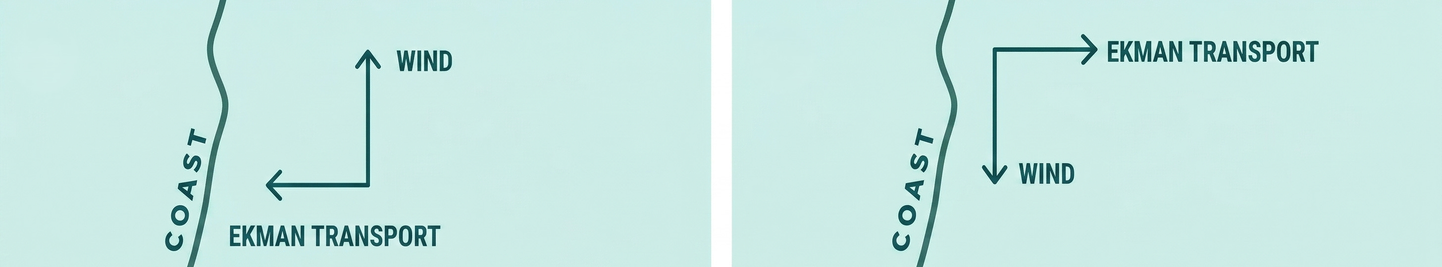
On the left, ekman transport pushes the surface water toward the coast.
Since the water hits the solid land and has nowhere else to go, it starts to pile up.
This “hill” of water gets heavy, and gravity forces the warm surface water to sink downward. This carries oxygen and heat from the surface into the deeper parts of the ocean.
On the right, the Ekman transport is moving in the opposite direction, which pulls the surface water away from the coast.
As the surface water moves out to sea, it leaves a “hole” or a gap behind. The fundamental principle of mass conservation drives this.
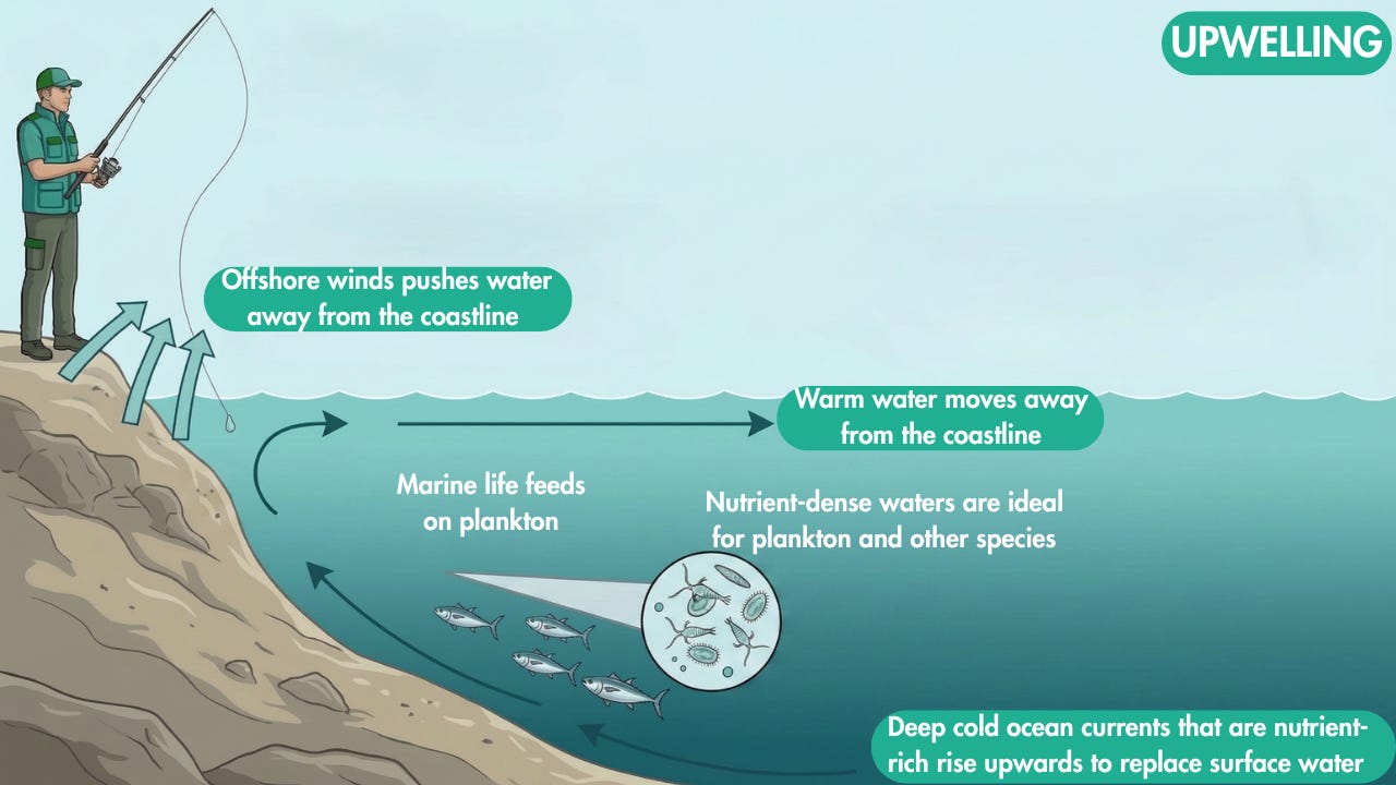
To fill that space, cold, nutrient-rich water from the deep ocean is sucked upward to the surface. This is why places with upwelling (like the coast of California or Peru) have very cold water but are teeming with fish, the deep water brings up nutrients for marine life.
Why upwelling is very important:
Deep ocean water is packed with nutrients. When upwelling pushes these to the sunlit surface, they act as a “super-fertilizer” for phytoplankton and macroalgae (seaweed).
These plant blooms provide the primary energy source for the ocean. Without upwelling, we wouldn’t have the massive populations of fish, seabirds, and whales that thrive in these zones.
Despite making up a tiny fraction of the ocean’s surface, upwelling zones provide nearly 40% of the world’s total fish catch, making them essential for the global economy and food supply.
Upwelling helps cool the planet by bringing cold water to the surface and moving heat into the deep ocean. In places like the Southern Ocean, it fuels the growth of plants that absorb massive amounts of carbon dioxide.
It can be a double-edged sword; in Antarctica, upwelling can sometimes bring slightly warmer deep water toward the coast, which may contribute to the melting of ice shelves from below.
Takeaway Vertical water movement is driven by Ekman suction and pumping, which act as a mechanical pump for the deeper ocean. When Ekman transport pulls surface water away from a coastline or a central point, cold, nutrient-rich deep water rises to fill the gap—a process called upwelling that fuels 50% of the world’s fish catch and regulates global carbon levels. Conversely, when transport pushes water toward a coast or center, it piles up and sinks, creating downwelling that carries vital oxygen and heat into the deep ocean.
4. Deep ocean circulation
While the surface is driven by wind, the vast majority of the ocean’s volume is moved by density gradients in a process known as thermohaline circulation. Seawater density is governed by two factors: temperature (thermo) and salt content (haline).
In extreme polar regions, two things happen: intense cooling makes the water molecules contract and become more compact, and the formation of sea ice leaves salt behind in a process called “brine rejection.” This combination creates water that is exceptionally cold, salty, and heavy. Because it is much denser than the surrounding water, it sinks rapidly from the surface to the seafloor, serving as the primary engine driving the Global Conveyor Belt.
This sinking creates two primary deep-water masses that reach different depths:
North Atlantic Deep Water (NADW): Formed in the subpolar North Atlantic (like the Labrador and Nordic seas), this water sinks and flows southward across the globe at depths typically ranging between 1,000 and 4,000 meters.
Antarctic Bottom Water (AABW): Formed on the continental shelves of Antarctica, this is the densest water mass in the global ocean. It cascades down the continental slope to the abyssal plains, spreading northward beneath the NADW. AABW occupies the deepest parts of all major ocean basins, generally existing below 2,000 meters and routinely reaching extreme depths of 4,000 to 6,000 meters
This sinking motion drives the deep limb of the Meridional Overturning Circulation (MOC), a slow, global-scale circulation pattern that travels across ocean basins and takes approximately 1,000 years to complete a single circuit.
Closing the loop
To complete this massive, millennial-scale global circuit, the deep waters that sank at the poles must eventually rise back to the surface. As these deep waters slowly travel through the ocean basins, turbulent mixing gradually makes them less dense. The actual vertical return of this deep water to the surface occurs very slowly across the ocean basins and is heavily assisted by strong wind-driven upwelling in the Southern Ocean, which pulls these ancient, deep waters back up the water column.
Takeaway The depths of the ocean are powered by thermohaline circulation, often called the Global Conveyor Belt, which is driven by differences in water density rather than wind. In polar regions, freezing sea ice leaves behind salt (brine rejection), creating water that is exceptionally cold, salty, and dense enough to sink to the abyssal floor. This sinking initiates the Meridional Overturning Circulation (MOC), a massive underwater circuit that takes roughly 1,000 years to complete, eventually returning to the surface through turbulent mixing and upwelling to redistribute heat and nutrients across the entire planet.
5. How ocean circulation affects companies
As climate change alters global ocean currents—disrupting thermal patterns and nutrient distribution—companies face mounting risks that impact their financial stability.
1. Physical risks to operations
Shifts in ocean movement directly threaten global logistics and the reliability of marine resources.
Maritime shipping & Just-in-Time delivery: Vessels rely on predictable currents to reduce fuel burn. If currents become less predictable or intensify, ships must fight stronger head currents, increasing operational costs and GHG emissions. This disrupts Just-in-Time logistics, forcing companies to increase buffer times in their schedules, which ties up more capital in transit.
Marine Renewable Energy: Offshore wind and tidal projects depend on stable coastal flows. Unpredictable shifts can reduce the efficiency of underwater turbines and increase maintenance costs for expensive offshore infrastructure.
Commercial Fisheries: Ocean currents determine the location of nutrient-rich waters. Shifting patterns cause commercial fish stocks to migrate, forcing fleets to travel longer distances and threatening the seafood supply chain.
2. Regulatory & insurance risks
Asset insurability: Ocean circulation affects sea-level rise and storm surges. As currents like the Gulf Stream shift, coastal flooding patterns change. This directly impacts the insurability of coastal assets—from real estate to ports—potentially leading to stranded assets or skyrocketing insurance premiums.
Compliance: Increased oceanic volatility can lead to stricter international regulations. Companies may face green shipping mandates, sudden closures of traditional fishing grounds, or new penalties for agricultural runoff that creates coastal dead zones.
3. Reputational and social risks
Industries face intense scrutiny for their role in marine degradation. The creation of hypoxic dead zones—such as the 6,000-square-mile zone in the Gulf of Mexico—or emissions that threaten the AMOC conveyor belt can lead to divestment and loss of consumer trust.
6. Moving to a circular blue economy
To survive these shifts, firms are adopting a circular blue economy model that focuses on regenerating marine systems.
Invest in blue carbon and ecosystem restoration: The deep ocean conveyor belt (thermohaline circulation) is highly vulnerable to global warming and the influx of freshwater from melting ice. To help stabilize the climate and protect this circulation, companies can invest in nature-based solutions and the blue economy. This includes funding the restoration of blue carbon ecosystems such as mangroves, seagrass meadows, and salt marshes. These marine habitats are among the most carbon-dense ecosystems on Earth, sequestering massive amounts of carbon dioxide while providing natural flood protection and improving local water quality.
Adopt the LEAP framework for risk management: Corporations can systematically address their impacts on water and marine resources by utilizing the LEAP approach (Locate, Evaluate, Assess, Prepare) developed by the Taskforce on Nature-related Financial Disclosures (TNFD). This framework guides companies to map out exactly where their operations and supply chains intersect with sensitive water basins. Once these risks are identified, companies can apply the AR3T mitigation hierarchy, meaning they take structured action to Avoid, Reduce, Regenerate, Restore, and Transform their environmental footprint


![[INSIGHT] How to identify water risk in your supply chain: The LEAP approach in practice](https://substackcdn.com/image/fetch/$s_!bjje!,w_140,h_140,c_fill,f_webp,q_auto:good,fl_progressive:steep,g_auto/https%3A%2F%2Fsubstack-post-media.s3.amazonaws.com%2Fpublic%2Fimages%2F18e8a8aa-bc84-4e32-9322-b074b22a517d_1857x1731.png)